Dhorpatan Treks
- Duration:14 Day(s)
- Destination:Nepal
- Grade:Easy
Dhorpatan treks .kml Overview
Dhorpatan Treks – Where Mountains, Culture & History Meet
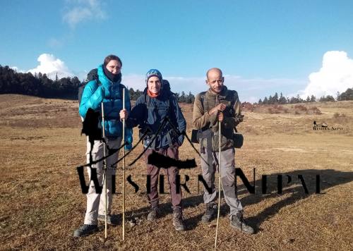
Tucked between the towering massifs of the Dhaulagiri and Annapurna ranges lies Dhorpatan, a high-altitude plateau that feels like a different world. It is not just a trekking destination; it is a living museum of Himalayan culture, a refuge for wildlife, and a place where history, tradition, and nature intertwine.
About Dhorpatan
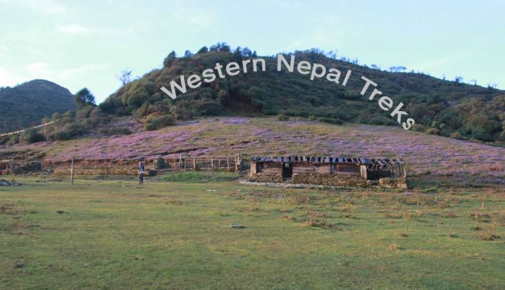
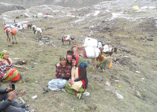
Dhorpatan sits at an elevation of about 2,800–3,200 meters, spread across the Rukum, Myagdi, and Baglung districts. Its vast alpine meadows open to snow peaks, grazing yak herds, and wildflower-studded pastures. The name “Dhorpatan” comes from Dhor (meadow) and Patan (flat open land) — an apt description of its sweeping grasslands.
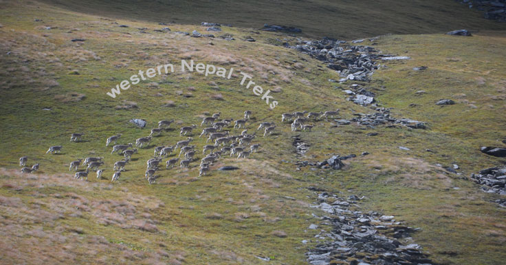
Dhorpatan Hunting Reserve
Established in 1987, the Dhorpatan Hunting Reserve is the only legal hunting reserve in Nepal, covering 1,325 km⊃2;. It is home to endangered Himalayan species, including:
Blue sheep (Naur), a prized game species.
Himalayan thar, goral, and musk deer.
Rare birds like the Himalayan monal (Danphe), Nepal’s national bird.
The reserve is divided into seven blocks, each with designated hunting quotas and seasons, managed under strict government regulation. Foreign hunters pay for special permits, and local communities benefit through revenue-sharing.
While hunting may sound unusual for a trekking destination, the reserve also serves as a conservation model, balancing sustainable harvests with habitat protection. Outside the hunting blocks, the meadows and forests are perfect for trekking and wildlife photography.
Yarsagumba Harvesting
From late May to early July, Dhorpatan’s meadows (Falgune) turn into bustling seasonal camps for Yarsagumba hunters.
Yarsagumba (Ophiocordyceps sinensis) is a rare caterpillar fungus valued in traditional medicine as an aphrodisiac and energy tonic.
It fetches extremely high prices, especially in China, where it is sometimes called “Himalayan Viagra.”
During this season, entire families set up tents in the high meadows, meticulously searching for the tiny fungus that hides in the grass. This harvest is an important income source for many mountain communities — though it also brings challenges in resource management and environmental impact.
Uttar Ganga Valley
The Uttar Ganga River flows through the heart of Dhorpatan, nourishing its valleys and providing water to villages downstream. The valley is rich in biodiversity — from alpine herbs like Jatamansi to medicinal shrubs used in Tibetan and Ayurvedic healing. The river is also a lifeline for wildlife in the hunting reserve.
Banpo Religion & Tibetan Medicine
Dhorpatan is not just a crossroads of trade and migration — it’s also a cultural melting pot. One of the oldest traditions still alive here is the Bon (Banpo) religion, a pre-Buddhist spiritual system originating in Tibet.
Bon practices involve nature worship, sacred mountains, and elaborate rituals to appease local deities.
In Dhorpatan, Bon culture mingles with Tibetan Buddhism, creating a unique spiritual heritage.
The Banpo Monastery here is a quiet but significant center of learning, and local healers still practice Tibetan medicine (Sowa Rigpa). These doctors use centuries-old herbal formulas made from plants gathered in the surrounding mountains — including rare species found only in high-altitude Nepal.
Why Dhorpatan Feels Different
Unlike more commercial trekking regions like Annapurna or Everest, Dhorpatan retains a raw, authentic atmosphere:
No crowded teahouses: most stays are in family homes or basic lodges and Camping
Wild and open landscapes: vast meadows, untouched forests, and isolated hamlets.
Layered history: from ancient trade routes to being a stronghold during Nepal’s Maoist insurgency.
Combining Nature, Culture & History
A Dhorpatan trek offers:
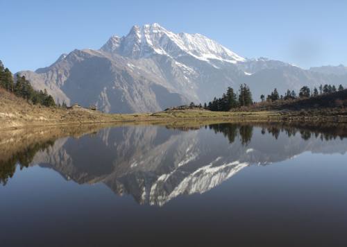
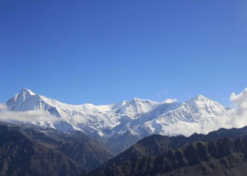
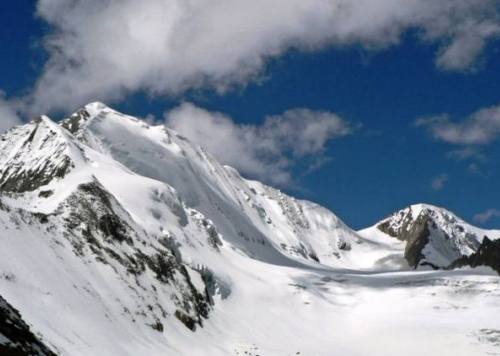
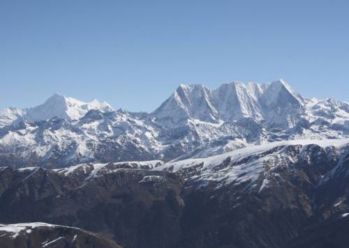
Panoramic Himalayan views: Dhaulagiri I (8,172 m), Putha Hiunchuli (7,246 m), Churen Himal (7,371 m), Sisne Himal.
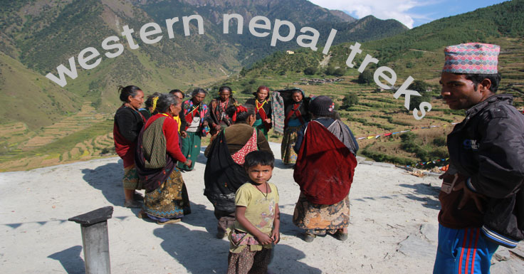
Cultural immersion: Kham Magar hospitality, Pun Magar traditions, Gurung
settlements.
Wildlife encounters: blue sheep, musk deer, Himalayan pheasants.
Unique seasonal activities: Yarsagumba harvesting, livestock migration, highland festivals.
A Trek for the Curious & Adventurous
Dhorpatan is for trekkers who want more than just mountains it’s for those curious about living traditions, remote histories, and the delicate balance between humans and nature in the high Himalaya.
Whether you’re walking through flower-filled meadows at Jalal Pass, sharing millet beer with locals in Maikot, learning about Bon rituals, or watching blue sheep graze beneath snow peaks, this journey will feel both intimate and epic.
If you are really interested with this trek then, I can also prepare an alternative Day 13 route breakdown showing the trekking connection between Maikot, Takasera, and Rukumkot in case the group prefers to move rather than stay in one place. That way it works for both cultural rest days and active trekking days. Would you like me to do that?
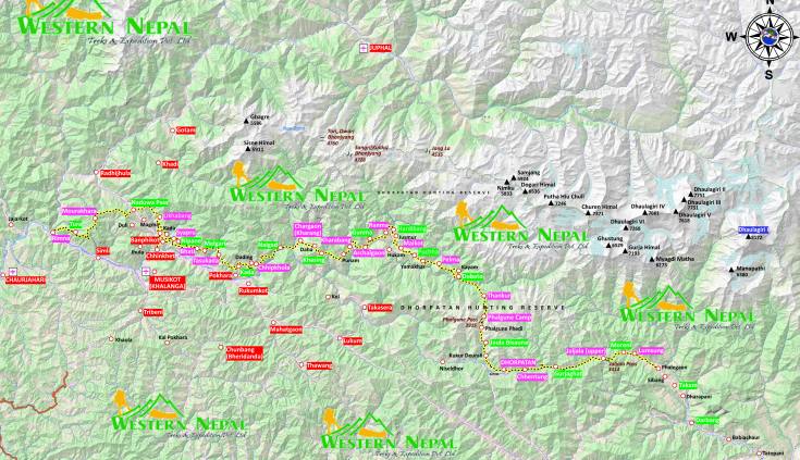
Day to day outline itinerary
Day 01: Day 01: Kathmandu – Pokhara – Beni By Microbus (294 km / 10 hrs)
Day 02: Day 02: Beni – Dharabang (Lunch) – Lumsung (46 km / 6 hrs)
Day 03: Day 03: Lumsung – Moreni (Lunch) – Jaljala (7 km / 6.5 hrs)
Day 04: Day 04: Jaljala – Gurjaghat (Lunch) – Chhentung (16 km / 9 hrs)
Day 05: Day 05: Chhentung – Dhorpatan (7 km / 2.5 hrs) (Half Rest Day)
Day 06: Day 06: Dhorpatan – Jaulabishauna (Lunch) – Thankur (20 km / 10 hrs)
Day 07: Day 07: Thankur – Dobato (Pack Lunch) – Pelma (13 km / 8.5 hrs)
Day 08: Day 08: Pelma – Puchhar (Lunch) – Maikot (11 km / 6 hrs)
Day 09: Day 09: Maikot (Rest Day Option)
Day 10: Day 10: Maikot to Jusmur (Lunch) & Ranma (7 km / 4 hrs)
Day 11: Day 11: Ranma to Takasera & Rukumkot (78 km) 5hrs
Day 12: Day 12: Rukumkot to Pokhara via Mid-Hill Highway by bus( 250km/ 12hrs)
Day 13: Day 13:Reserve Day (flexible program)
Day 14: Day 14: Pokhara -Kathmandu by Bus (205km / 7hrs )
Detail Itinerary
Day 01Day 01: Kathmandu – Pokhara – Beni By Microbus (294 km / 10 hrs)After breakfast in Kathmandu, drive to Pokhara along the Prithvi Highway, following the Trishuli and later the Marsyangdi rivers. Enjoy views of terraced hillsides, small towns, and glimpses of the Annapurna range on clear days. Lunch en route in Pokhara, then continue west along the Baglung–Beni road, following the Kali Gandaki River. Overnight in Beni (830 m), the district headquarters of Myagdi and gateway to Dhorpatan.
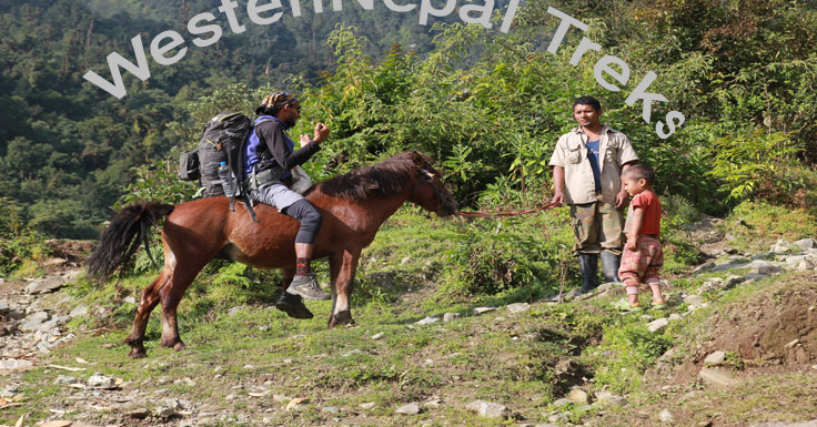
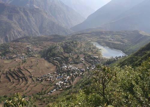
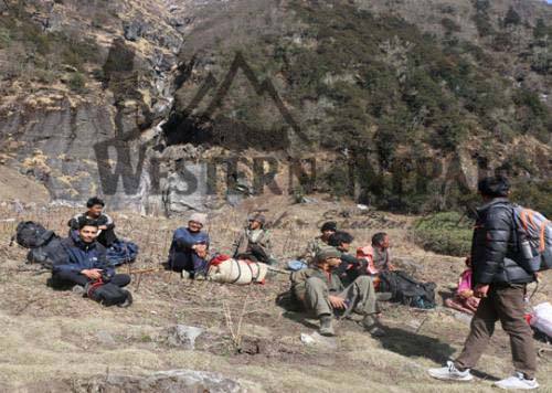
Day 02Day 02: Beni – Dharabang (Lunch) – Lumsung (46 km / 6 hrs)Depart Beni by local jeep or vehicle, following a rough but scenic road along the Myagdi Khola. Pass through lush valleys and small settlements such as Darbang, where you’ll have lunch. Continue toward Lumsung (approx. 1,450 m), a quiet Gurung and Magar village surrounded by terraced fields and forests. Overnight in Lumsung.
Day 03Day 03: Lumsung – Moreni (Lunch) – Jaljala (7 km / 6.5 hrs)The day begins with a steady uphill walk through mixed forest and rhododendron groves. Stop for lunch at Moreni, then climb further to reach Jaljala (approx. 3,430 m). This high meadow offers panoramic views of Mt. Dhaulagiri and surrounding peaks. The area is known for its seasonal wildflowers in spring. Overnight in Jaljala.
Day 04Day 04: Jaljala – Gurjaghat (Lunch) – Chhentung (16 km / 9 hrs)Descend gently through high-altitude pastures, often seeing grazing yaks. The trail passes through Gurjaghat, a small settlement used by herders, where you’ll have lunch. Continue to Chhentung, passing alpine meadows and forests. Views of the Dhaulagiri range accompany much of the day. Overnight in Chhentung.
Day 05Day 05: Chhentung – Dhorpatan (7 km / 2.5 hrs) (Half Rest Day)A short and relatively easy trek leads you to Dhorpatan (2,870 m), the only hunting reserve in Nepal. Arrive by late morning for lunch. The afternoon is free for rest or short walks to explore the villages, monasteries, and open grasslands where blue sheep are sometimes spotted. Overnight in Dhorpatan.
Day 06Day 06: Dhorpatan – Jaulabishauna (Lunch) – Thankur (20 km / 10 hrs)A long trekking day through forested paths and meadows, with occasional river crossings. Stop for lunch in Jaulabishauna, a small hamlet along the trail. Continue to Thankur (approx. 3,100 m), where you’ll camp or stay in a local lodge. This area is remote, with few settlements and plenty of birdlife.
Day 07Day 07: Thankur – Dobato (Pack Lunch) – Pelma (13 km / 8.5 hrs)Climb gradually through forests and alpine ridges, carrying a packed lunch as there are no teahouses along the way. From Dobato, continue over undulating terrain to Pelma, a small rural village with views of surrounding hills and farmlands. Overnight in Pelma.
Day 08Day 08: Pelma – Puchhar (Lunch) – Maikot (11 km / 6 hrs)An easier day, walking through cultivated terraces and small settlements. Stop for lunch in Puchhar, then ascend gradually to Maikot, an important historical and cultural village of the Magar people. Overnight in Maikot (approx. 2,300 m).
Day 09Day 09: Maikot (Rest Day Option)Optional rest day to explore Maikot’s cultural heritage, visit local homes, or take short hikes to surrounding ridges for views of Dhaulagiri and nearby hills. This is also a good day for acclimatization and catching up on laundry or gear repairs.
Day 10Day 10: Maikot to Jusmur (Lunch) & Ranma (7 km / 4 hrs)A short day’s walk through gentle terrain, passing small farms and forests. Stop for lunch in Jusmur before continuing to Ranma, a peaceful hilltop village. The afternoon is free to rest or enjoy sunset views over the surrounding valleys. Overnight in Ranma.
Day 11Day 11: Ranma to Takasera & Rukumkot (78 km) 5hrsStart your day with a short 5 km journey from Ranma to Gara, but note that there is no bridge over the Sanoveri River, so crossing may require local assistance or careful navigation. From Gara, continue 29 km to the culturally rich Magar village of Takasera, where you can enjoy a lunch break and experience the local hospitality. The route then leads 20 km to Kakrai, a key junction for those heading toward Kathmandu. However, it's important to note that there is no bridge over the Uttarganga River between Takasera and Talno Sera, so plan accordingly. Instead of staying in Kakrai, travel an additional 24 km west to Rukumkot—the former district headquarters of Rukum—which offers better accommodation and an opportunity to explore the area's historical significance, making it an ideal place to rest and recharge.
Day 12Day 12: Rukumkot to Pokhara via Mid-Hill Highway by bus( 250km/ 12hrs)Today’s journey takes you from the tranquil town of Rukumkot to the vibrant city of Pokhara, following the scenic Mid-Hill Highway. The route winds through lush hills, terraced fields, and charming villages, offering panoramic views of the Himalayan foothills. Expect a long but rewarding drive of approximately 10 -12 hours, depending on road conditions. As you descend into Pokhara Valley, the climate becomes warmer and more humid. Upon arrival, relax by Phewa Lake and enjoy the comforts of the lakeside city, a stark contrast to the remoteness of Rukumkot.
Day 13Day 13:Reserve Day (flexible program)This extra day can be used for rest, exploration, or to adjust the program in case of delays due to weather or trail conditions.
Options:
Makot A traditional Magar settlement, short hikes to surrounding ridges offer panoramic views. (Approx. 4–6 km walking depending on chosen trail)
Takasera – Historic town known for its cultural heritage and old stone houses; gentle local walks or cultural exploration. (Approx. 3–5 km within town and surroundings)
Rukumkot – Lakeside village with scenic Rukmini Tal and views of Sisne Himal; ideal for a relaxed walk. (Approx. 2–4 km easy walking)
Day 14Day 14: Pokhara -Kathmandu by Bus (205km / 7hrs )Morning transfer to Pokhara Airport for a short 25–30 min flight to Kathmandu. Upon arrival, transfer to the hotel. Free afternoon for shopping or sightseeing in the capital. (Overland option: 205km, 6–7 hrs by private vehicle along Prithvi Highway)
Company Profile
Related Trips
SISNE UPPER Trek
22 Days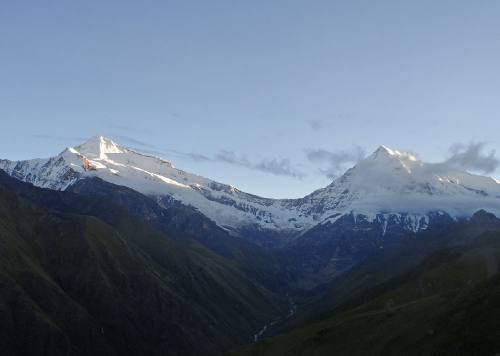
WEST DHAULAGIRI LOWER Trek
22 Days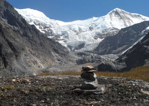
WEST DHAULAGIRI UPPER Trek
22 Days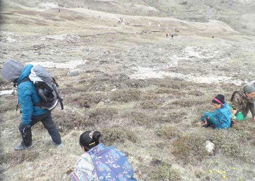
YARSA Trek
16 Days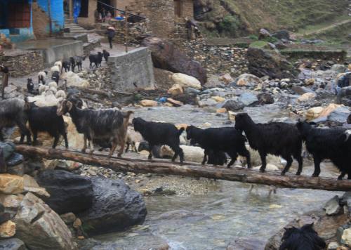
THAKUR JEE or SAI KUMARI Trek
15 Days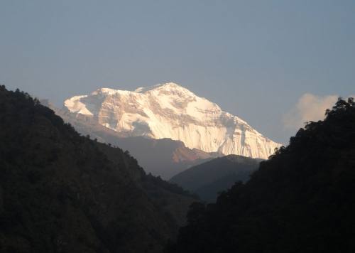
DHAULAGIRI SANCTUARY Trek
14 Days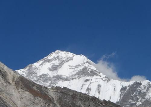
GUERRILLA TREK
20 Days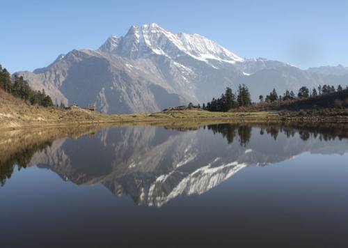
SISNE TREK
15 Days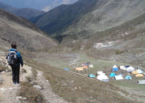
YARSA ROUND TREK
16 Days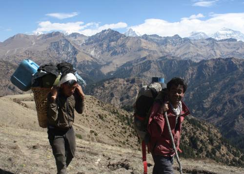
DHORPATAN - SISNE TREK
20 Days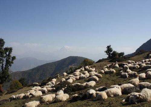
SISNE LOWER TREK
17 Days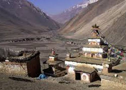
UPPER DOLPO TREK
24 Days
RARA - KHAPTAD TREK
12 Days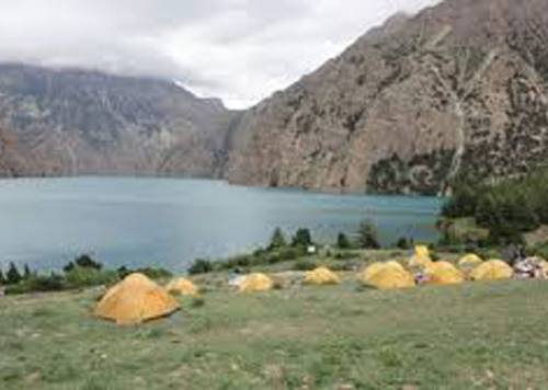
LOWER DOLPO TREK
14 Days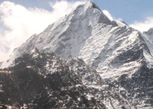
SISNE ROUND TREK
19 Days
API SAIPAL BASE CAMP TREK
28 Days
API KHAPTAD TREK
21 Days
Sisne -Phoksundo Trek
16 Days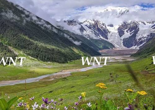
SAIPAL ROUND TREK
30 Days
Phoksundo to Rara Trek
23 Days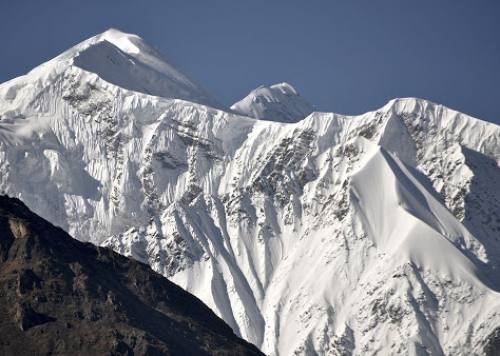
API BASE CAMP TREK
12 Days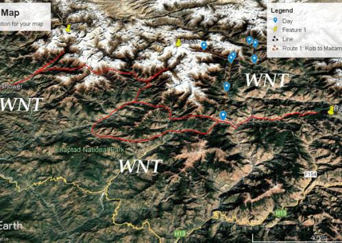
API CULTURAL TREK
17 Days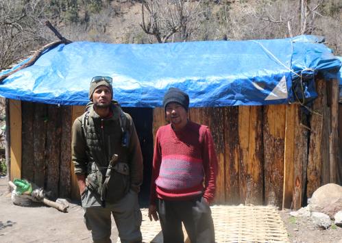
CHAKHURE TREK
14 Days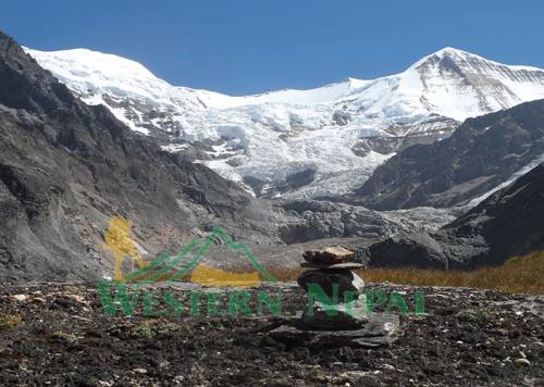
West Dhaulagiri Base Camp Trek
17 Days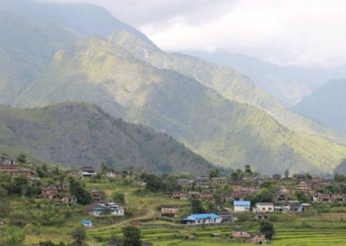
DHAULAGIRI ROUND Trek
18 DaysWHAT DO PEOPLE SAY ABOUT US?

Inside Rukum paradise
The guerrilla trek provides a total immersion in Magar's community that maintiens its authentic and traditional culture. The homestay experience is unique. Between villages, landscapes from West Dhaulagiri range are magnifient. Discovering Rukum with Man…
- Brigitte and Laurent
ContinueA beautiful trek in autumn
Trekking with Man Dai was really nice and i never felt unsave on the way. It was challenging but we walked for everyone in a good speed! It was a incredible experience and i will…
- Christiane Wolfgruber
ContinueAmazing Trek
Completed the Guerilla Trek September 2022. With Man in charge, things went smoothly as possible in Nepal. He seems to know someone in most remote villages, very useful for fascinating home stays. Incredible scenery with…
- Peter Hoffmann
Continueguerrilla trek
Très beau trek dans le Rukum région situé à l'ouest du Népal . Hors les sentiers battu un périple au milieu de paysages de moyenne montagne ,traversant des villages typiques de culture Magar . Manbahadur,…
- benais
ContinueTowner
Man is the Man! Four of us did this trek along the crests and to the villages and it was epic. No crowds. In fact, we didn’t see any other foreigners in two weeks. Wanna…
- Hank
ContinueApi Base Camp - Rashi Pass - Khaptad National Park
Trekking in Far-Western Nepal was a mix of stunning scenery and rich culture. The trails took us through remote villages and brought us in contact with many friendly locals. The Himalayan views were incredible, and…
- Eric
Continue
Good Experience with Western Nepal Treks
My experience with Western Nepal Treks was amazing! I felt in good hands all the way and could enjoy the landscape and people around. I had nice talk and i learned more about the culture. I…
- Erick
Continue